Guatemala |
||||||||||||||||||||||||
|
Click the points on the map to learn more.
 |
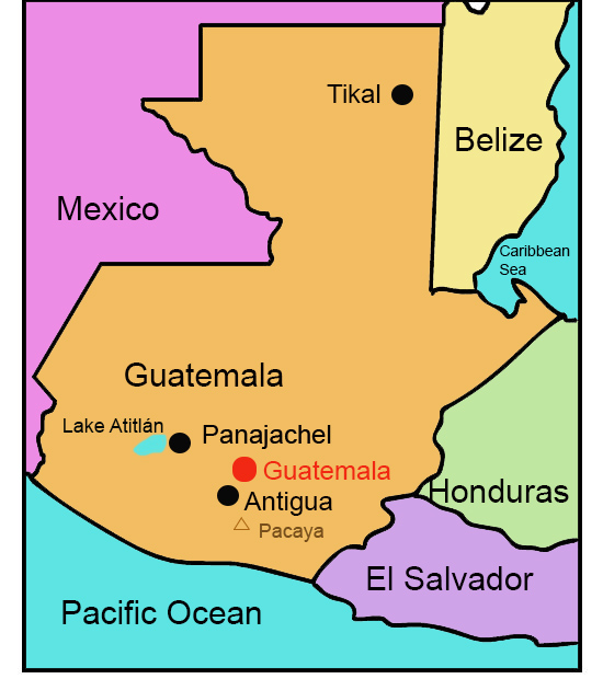
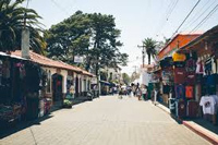
Antigua, GuatemalaUntil an earthquake destroyed the town in 1773, Antigua (then known as Santiago de los Caballeros) was the capital of Guatemala. Previously considered a political and economic center, Antigua now draws visitors for its quiet and picturesque surroundings. Antigua is flanked by three volcanoes, and is less than 30 miles away from Guatemala City. |
| Back to Map | |
 |
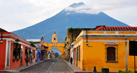
Guatemala (Guatemala City)Guatemala’s capital has a population of one million, making it not only the largest city in Guatemala, but the largest city in Central America. It was founded in 1776 to replace Antigua, after the earthquake destroyed the city three years earlier. Today, Guatemala City is the country's center for commerce, banking, government, and transportation. |
| Back to Map | |
 |
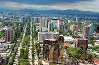
Lake AtitlanLake Atitlįn was formed when a volcano erupted 84,000 years ago and collapsed. The deepest lake in Central America, Lake Atitlįn is 900 feet deep with an area of 48 square miles. The lake draws many tourists to swim, boat, kayak, and jetski in its waters, as well as to hike and bike between the many villages surrounding it. |
| Back to Map | |
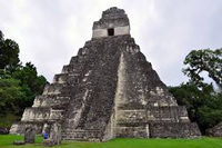 |
TikalTikal was once a bustling Mayan city in northern Guatemala. At its peak, Tikal was a hub of political, economic, and social life for the Maya. It holds some 3,000 Maya buildings dating from 600 B.C. to A.D. 900. Today, the ancient city is a popular tourist destination attracting thousands of visitors each year. |
| Back to Map | |
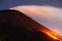 |
Volcįn PacayaVolcįn Pacaya is an active volcano near Antigua. It last erupted in June 2015 and erupted frequently since 1965, making it the most active volcano in Guatemala. It rises to a height of 8,372 feet. |
| Back to Map | |
 |
PanajachelPanajachel sits in the southern highlands of Guatemala. The city has views of Lake Atitlįn and three nearby volcanoes. During the time the Spanish were conquering Guatemala, Panajachel was the location of a large battle in which the Spanish defeated the Tzutuhils. Soon after, a church was built in Panajachel as the Spanish used the town to convert the Indians to Catholicism.
|
| Back to Map | |
| Population: | 15.47 million |
| Area: | 42,042 square miles |
| Capital City: | Guatemala City |
| Largest City: | Guatemala City |
| Currency: | Quetzel |
| Official Language: | Spanish |
| GDP (Gross Domestic Product) | $53.8 billion |
- More than half of todays Guatemalans are descendants of the indigenous Maya peoples, and speak some 24 indigenous languages
- "Ladinos" are Guatemalans with mixed Maya-Spanish ancestry
- Guatemala declared independence from Spain in 1821
- Guatemala is home to 30 volcanoes, some of which are still active
- The majority of the country is mountainous and heavily forested
- Guatemala has no national religion
- Guatemala’s currency shares a name with the colorful quetzal bird - an endangered species living high in Guatemala’s mountainous rainforests
- 1996 marked the end of a 36-year guerrilla war within the country
- Guatemala exported 224,869 tons of coffee in 2015. Raw sugar, bananas, and coffee are Guatemala's top three exports
- Volcįn Tajumulco is the highest point in Central America, reaching nearly 14,000 feet
|
|
 |
|
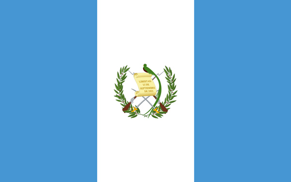
The two blue sections of the flag represent the Pacific Ocean and Caribbean Sea, which flank Guatemala’s shores. The white symbolizes purity and peace. The quetzal bird represents liberty, the bay laurel crown represents victory, and the crossed swords represent honor. The scroll is signed with the day of Guatemala’s independence from Spain - September 15, 1821. |
|